Archaeological Discoveries at Llanllyr – Nuns, Trees and 3D Technology
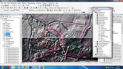
Data from all of the archaeological excavations and surveys are kept in a Project GIS (Geographic Information System). Lidar data show here is at 1m resolution supplied by Environment Agency. This has been processed to supply a hillshade bitmap based on topographical heights. You can see rectangular and linear features within the overgrown 'fishponds' area circled in red.
This blog was written by Dr Jemma Bezant, UWTSD Lecturer in Archaeology, and a member of the excavation team at Llanllyr Mansion. They say every good archaeologist has a wish list. A list of fabulous, intriguing and exciting places where …
Archaeological Discoveries at Llanllyr – Nuns, Trees and 3D Technology Read more »